The upcoming lesson will cover some geographic basics, including location of continents, certain nations, and major geographic features, such as mountains, seas, oceans, rivers, and grasslands.
The previous lesson reviewed some basic economic concepts, including the price index, gross domestic product, and exchange values.
The natural world has shaped the contours of our existence from earliest prehistory up to the present. Indeed, civilization itself only sprang into being after the glaciers of the last ice age had receded from North America and Northern Europe. Paleoanthropological studies show that humans intermittently practiced a kind of proto-farming for thousands of years prior to the Agricultural Revolution. They did not, however, intervene intensively in the breeding and cultivating of crops, nor did their semi-wild gardens become mainstays of the prehistoric diet. Within a few thousand years of the present interglacial period, however, full-scale agriculture was practiced by cultures around the world. Scientists still debate the reason for a sudden, global interest in a technology that had been only sporadically employed before that time, but many believe that the climactic instability inherent in the last ice age prevented cultures from being able to develop long-lasting permanent settlements. After the last ice age, however, the climate stabilized sufficiently to allow for long-term agricultural investment.
The other major environmental factor necessary to the rise of civilization was water, usually in the form of a regularly-flooding river. All of the major early civilizations arose in major river valleys: Sumer and the subsequent Mesopotamian civilizations developed in the fertile land between the Tigris and Euphrates rivers; the Egyptian Dynasties came to power along the Nile river; and the Harappan civilization of India sprang up by the Indus. Rivers, aquifers, and other bodies of water sustained agriculture and facilitated travel, trade, communication, as well as the spread of ideas. Water and its movement (shown below) is the lynchpin of human life. This will be covered in greater detail in the Life Science chapter coming up.
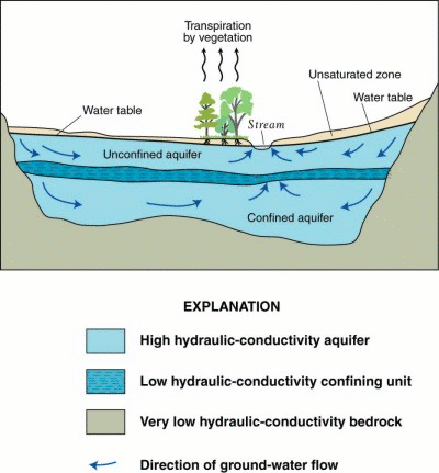
The water cycle
The environment affected the nature of ancient civilizations in other ways as well. Ancient Greece, for example, was politically fragmented because of its mountainous terrain. Its extensive coastline encouraged the Greeks to develop an interest in the sea and in trade, spurring their colonization of parts of modern Italy and Asia Minor. Similarly, early Roman civilization was fostered by its mountains and the sea, which helped to repel intruders while Rome established its strength internally.
Rivers, ports, and the availability of natural resources continue to play a major role in the development and health of nations. The destruction of the port of New Orleans as a result of hurricane Katrina sent economic ripples throughout the country, while fights within and between nations over increasingly scarce water resources are an escalating problem.
The surface area of the Earth is more than 195,000,000 square miles, and much of it has been mapped by geographers over the last millennia. As you can see from Johannes Kepler’s map below, thoughts about the Earth as a whole and its attendant features are not a new matter.
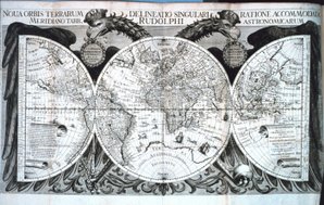
Kepler’s map
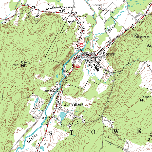
Indeed, maps probably pre-dated written language; one of the oldest is found on the wall in the Catal Hyuk, an ancient site in modern-day Turkey from about 6000 BCE. Click on the links below to review different styles of maps and the information they convey.
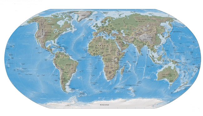
Spend some time reviewing these modern-day maps to brush up on your world geography skills.
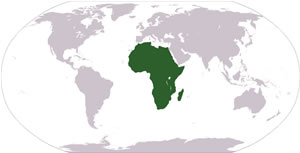 |
AfricaAfrica is the world’s second-largest continent. Including its adjacent islands, Africa covers almost 12 million square miles, and makes up over 20 percent of the total land area on the Earth. The continent is separated from Europe by the Mediterranean Sea, and joined to Asia by the Isthmus of Suez. Africa also boasts the second highest population of any continent, and, with over 800 million inhabitants, accounts for about one-seventh of the world’s population. Africa is thought to be the oldest inhabited continent, and perhaps the origin point of the human race; nonetheless, it is considered the world’s poorest continent. Agricultural goods and mineral resources are the main economic products of much of the continent. |
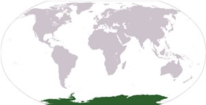 |
AntarcticaAntarctica is the continent that surrounds the Earth’s South Pole. With an area of approximately 8 million square miles, it is the world’s fifth largest continent and is also the continent with the highest average altitude and the lowest average humidity of any continent on the Earth. It is the coldest place on earth. The annual average temperature is -50°C (-58°F). Summer temperatures can reach as high as -30°C (-22°F). This landmass is almost entirely covered with ice but is also the world’s largest desert. Although Antarctica has no permanent residents, a number of governments maintain permanent research stations throughout the continent. It is estimated that about 1,000 people live in Antarctica in base camps, although this number varies widely by season. |
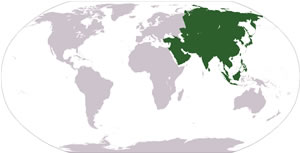 |
AsiaAsia is the continent that makes up the central and eastern part of Eurasia (Europe and Asia combined). Asia is also joined to Africa by the Isthmus of Suez. It is the largest continent in the world in terms of land area. Asia is also the world’s most populous continent, with about 60 percent of the human population. The continent is rich in natural resources, including petroleum and iron. Agricultural products include rice, wheat, and chicken. Forestry is extensive throughout Asia except Southwest and Central Asia. Manufacturing in Asia has traditionally been strongest in East and Southeast Asia, and varies from manufacturing cheap goods such as toys to high-tech goods. One of the major employers in manufacturing in Asia is the textile industry. Much of the world’s supply of clothing and footwear now originates in Southeast Asia. |
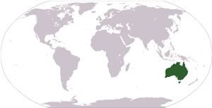 |
AustraliaOriginally settled by peoples of Southeast Asia around 40,000 years before the first Europeans (who arrived in the 17th century), Australia is mostly low plateau with deserts and a fertile plain in the southeast of the nation. Australia’s economy is highly developed and capitalistic. Its major resources include diamonds, natural gas, and petroleum. While it is the smallest of the seven continents, it is the world’s sixth largest nation in terms of square miles. |
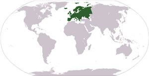 |
EuropeWhile it may better fit the definition of a subcontinent, Europe is usually labeled a continent. It comprises more than 40 countries and a dizzying array of languages and dialects. In terms of population, only Africa and Asia have more people. With its mountainous southern region, many peninsulas, and miles of coastline, Europe is one of the most physically complex continents. Twenty-five nations make up the European Union, an international group that decides issues on a wide variety of public policy. |
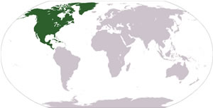 |
North AmericaStretching from the Arctic Ocean in the north and the Caribbean in the south, North America is the third-largest continent. It comprises Canada, the US, Mexico, Belize, Costa Rica, El Salvador, Guatemala, Honduras, Nicaragua, and Panama. The region also includes many territories of the US or other European countries. The continent is geographically diverse, containing mountainous ranges in the west and east, as well as prairies and deserts in the central regions. The North American economy is dominated by the US (about 12 trillion GDP) and Canada. |
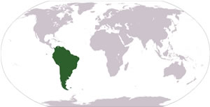 |
South AmericaMore than 350 million people live in South America, making it the fourth most populated continent. It is bordered in the north by the Panama Canal and stretches south to Cape Horn. South America’s largest country, both in terms of area and population, is Brazil. Its natural resources include tin, iron ore, and oil. The economies of many South American nations are unstable, and there is a tremendous gap between the wealthy and the poor. |
Click the Flash frame below for a segment about the rivers of the world.
More than 70% of the planet’s surface is covered by water. Let’s take a look at some of the Earth’s bodies of water that may be less well known.
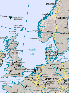 |
The North SeaThe North Sea connects to the Atlantic in the south through the Straits of Dover. In the northeast, it wraps around Denmark and makes its way through several different waterways, including the Kattegat and the busy, man-made Kiel Canal. |
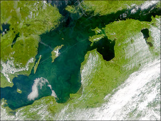 |
The Baltic SeaThe NASA image shows the Baltic Sea, which stretches northeast through the Gulf of Finland to reach Leningrad. To the north, it runs into the Gulf of Bothnia, a body of water that lies between Finland and Sweden. The Baltic Sea is the Earth’s largest collection of brackish water. |
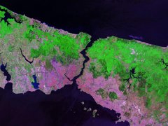 |
The BosphorusThis NASA image shows the Bosphorus, the waterway that connects the Mediterranean to the Black Sea. It is usually considered the dividing line between European Turkey and Asian Turkey. The Bosphorus has always been important strategically; when Constantine moved the Roman Empire’s capital east, he chose the site for the new capital Constantinople in 335. |
 |
The South China SeaThe South China Sea is the conventional name for the body of water that lies west of the Philippines and southeast of China. It is known as a “marginal sea,” meaning that it shares a significant amount of water with the nearby Pacific Ocean. The Sea features hundreds of tiny islands and stretches south into the Java Sea and north to the East China Sea and on through the Korea Strait into the Sea of Japan. |
The Earth is covered by many features that are undoubtedly familiar—mountains, valleys, and deserts, to name a few. Below is a review of some basic land features.
While similar to a prairie, a steppe is a large, treeless plain dominated by short grasses. The world’s largest area of steppes is east of the Volga River; these run all the way to the higher elevations of Mongolia.
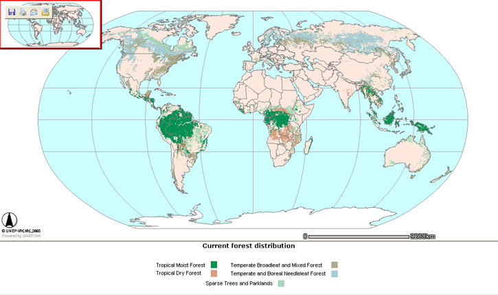
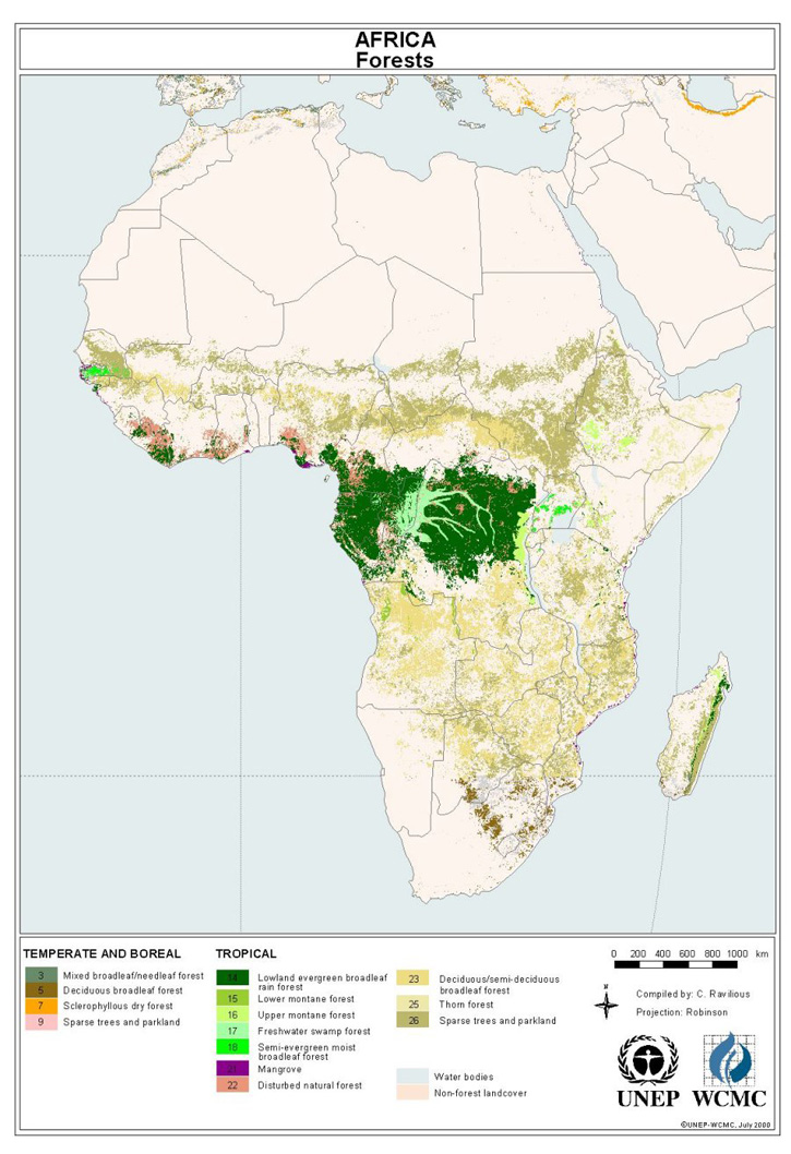
The term savanna usually refers to flat grasslands (with some trees). The savanna is a biome that features a fairly black-and-white seasonal pattern as long, dry winters give way to extremely rainy summers. Some of the best examples are in eastern Africa in Tanzania. Though Africa has a strong connection with the Sahara Desert, it is the home to many biomes. For an example, click here for a map of Africa showing its forests.
Covering almost 300,000 square miles, these are the South American lowlands that run throughout Argentina and Uruguay. Due to their humid and temperate climate, the Pampas grasslands are some of the best lands for grazing cattle; so much so that overgrazing is a serious threat to the biome.
The Earth is home to nearly 200 countries. Not all of them can be covered here, but a basic review follows. Check your nation knowledge by skipping the text and focusing on the maps. Can you identify these countries by sight and cities?
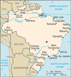 |
This largest country in the New World is also the only one whose national language is Portuguese, owing to its colonial relationship with Portugal. The Amazon rainforest that covers much of the country is nearly equal to the area of the United States, while the Amazon River is the second longest river in the world. Among the major exports from Brazil are coffee, rice, sugarcane, textiles, chemicals, and cement. |
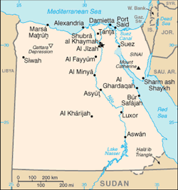 |
The civilization of the Nile valley stretches back to around 4500 BCE with the Neolithic Badarian people. The Nile has always been essential to Egypt’s prosperity, even though in modern times the fertile strip along the Nile river only comprises about 4% of the area of Egypt. Egypt’s principal exports are corn, rice, wheat, and textiles. |
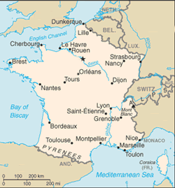 |
France is comprised of three geographic regions: mountains (on the southeastern and western borders), uplands (notably the Massif Central in south-central France), and rolling plains (in the northwest). The mountains have helped to define France, to discourage invaders, and to complicate France’s expansionist ambitions into Spain and Italy. Modern France is a presidential republic, though claimants to the French throne survive. It is powerful both agriculturally and industrially, as well as being the third largest nation in Europe (after Russia and Ukraine). Its principal exports are livestock, grains, iron, and steel. |
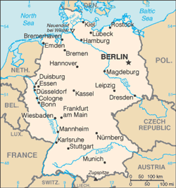 |
Reunited in 1990 after having been partitioned following World War II, Germany is industrially and financially important, though economic difficulties for its eastern portion remain a major concern. Germany has a rich agrarian plain in its north, even as pollution problems plague its forest regions. Germany produces grains, potatoes, steel, automobiles, and machinery, among other things. |
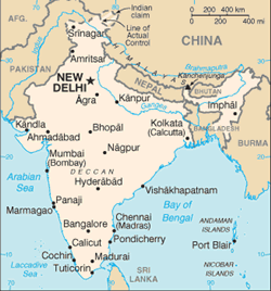 |
This diverse subcontinent is home to the second most populous nation on earth. India has been an independent country since the British withdrew in 1947. Although around two-thirds of the population supports itself by farming, India is also increasingly important in technology and services. It boasts a wealth of cosmopolitan, highly educated inhabitants who, along with the low cost of operating in India, have begun to attract multinational corporations. Despite this success, India suffers from endemic poverty, overpopulation, and environmental problems. |
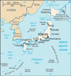 |
Modern Japan is a land that has experienced rapid transformation. In the past century, it has gone from a feudal country to a powerful empire, to an industrial and economic powerhouse. Japan has one of the highest standards of living in the world, although its economy, the world’s second-largest, has been in recession since the 1990s. Like the United Kingdom, Japan is a parliamentary democracy with a hereditary symbolic head of state, a position currently held by the Emperor Akihito. |
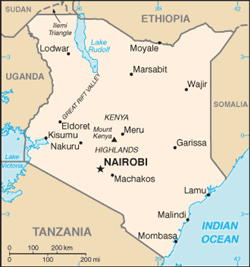 |
Kenya is the most prosperous nation in east Africa. Its plains are home to a rich diversity of wildlife, but only the southwestern highlands contain arable land. Kenya produces corn, coffee, tea, sisal, and pyrethrum. A former English colony, Kenya became a republic shortly after gaining its independence in 1963. Tourism is an important component of the economy of this staggeringly beautiful country. |
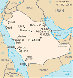 |
Saudi Arabia, constituting the bulk of the Arabian Peninsula, has become a wealthy nation since the discovery of its massive oil reserves (one-quarter of the world’s total) in the 1950s. A conservative, theocratic monarchy, Saudi Arabia is an important regional ally for the US. |
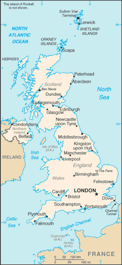 |
The United Kingdom (England, Scotland, and Northern Ireland) is a relatively small country that has played a major role in the development of geopolitics. At present, over one billion people speak English, and that number is expected to double in the next decade, a result of the influence of this enterprising nation. England’s early history was characterized by waves of immigrants; even the Celts are believed to have displaced or absorbed an earlier population. Later invaders included the Romans, the Saxons, various Scandinavian groups, and finally, the Normans. Since 1066, however, England’s seas have protected it from invasion. This protection helped it to become a major industrial and colonial power in the nineteenth and early twentieth centuries. Manufacturing and agriculture remain important components of the UK’s economy, while the service sector has gained increasing prominence. A constitutional monarchy, Britain is ruled by Parliament and its Prime Minister, while Queen Elizabeth II is the symbolic head of state. |
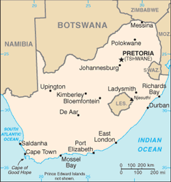 |
South Africa’s recent history has been shaped by its rich supply of natural resources, including gold, diamonds, platinum, and coal. Originally inhabited by indigenous African peoples such as the Khoikhoi, the Zulu, and the San, South Africa was colonized by Dutch settlers called the Boers in the eighteenth century. The Treaty of Vienna later gave the English a claim to South Africa, and they began to push back the Boer population. The discovery of valuable minerals in South Africa accelerated this process, culminating in the two Boer Wars at the turn of the century. Relations between the African natives and both sets of colonizers were even worse, a conflict vividly dramatized by the Zulu War. After independence, South Africa practiced apartheid, a form of official racial segregation that marginalized non-white South Africans. The African National Congress and Nelson Mandela, among others, resisted this policy, which was eradicated as a political system in 1994. Although the country faces serious social, economic, and health-related problems, the Truth and Reconciliation Commission that they established to deal with the aftermath of decades of apartheid and the abuses it engendered has become a model for other countries recovering from large-scale national injustice. |
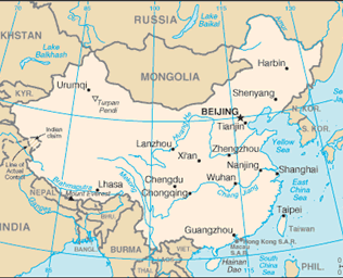 |
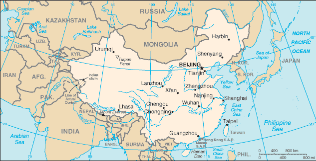
China has been protected by its ocean, mountains, and deserts for millennia. It is one of the oldest continuous civilizations in the world, famously the originator of paper, gunpowder, and pasta, among other innovations. China was ruled by a succession of dynasties until a revolution in 1911 established a short-lived republic. After a civil war in 1949, the existing Nationalist government was replaced by a communist government under Mao Zedong. Despite persistent high levels of government control over its citizens, China has become a major economic power as it adopts increasingly liberal economic policies. The development of the US relationship with China is a subject of significant interest as the world’s most populous country begins to seek access to the same kinds of goods and resources enjoyed by the rest of the developed world. |
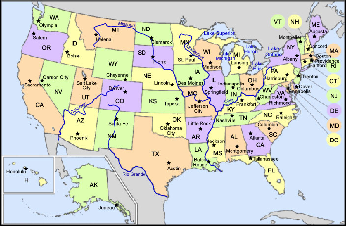
The Rockies begin as the Lewis Range as they enter the continental US in Montana. They run slightly southeast and leave the country in New Mexico.
The Appalachians lie in the eastern US and stretch from Georgia (about 300 miles northeast of Atlanta) to Maine. The 6,000 foot Mount Mitchell is the highest peak in the range in the US.
This range runs along the Pacific side of the country, separating the valleys of California from the deserts and mountains of Nevada and Oregon. In northern California, the Sierras meet up with the Cascades, which stretch into Canada.
Its name comes from an Objibwe word meaning “big river” and it’s the second-longest river in the US. The Mississippi River is an icon of the United States; it runs from its source Lake Itasca in northern Minnesota to the Gulf of Mexico in Louisiana.
While not as famous as its counterpart, the Mississippi, the Missouri River is the country’s longest. Its source is in the Rocky Mountains of Montana, and the river runs into the Mississippi just north of St. Louis, Missouri.
Providing the southern border of the US, the Rio Grande’s headwaters lie in the San Juan mountains of Colorado. The river flows through Colorado, New Mexico, and then into Texas where it empties into the Gulf of Mexico near Brownsville, Texas.
Actually a man-made reservoir on the border between Utah and Arizona, Lake Powell was created by Glen Canyon Dam, which dammed up the Colorado River. (Glen Canyon Dam was built between 1956 and 1963.)
Located in northern Utah, the Great Salt Lake is much saltier than the ocean. Three rivers (the Bear, the Weber, and the Jordan) feed the lake and dump huge amounts of minerals into its waters each year. It covers an area of about 1,500 square miles.
Five massive lakes that lie in midwestern US and Canada, the Great Lakes comprise Lake Michigan, Lake Superior, Lake Ontario, Lake Huron, and Lake Erie. Lake Ontario is connected to the St. Lawrence, and this combination makes the Great Lakes the largest freshwater collection on the planet.
Demography is the study of the characteristics of human populations and takes into account such features as size, growth, migration patterns, and distribution. Below is a review of some of the techniques of the discipline and some of the important demographic shifts in human history.
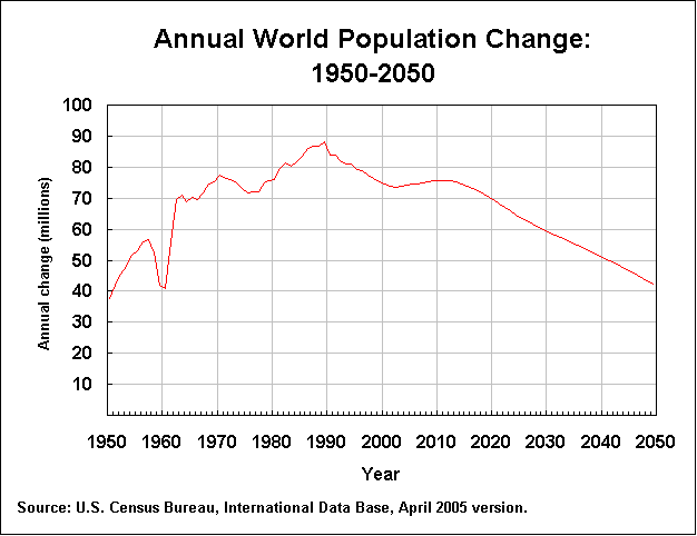
The world adds some 80 million people each year, and demographers study how this population growth affects the environment, the world’s food supply, the rate of disease, and other issues that are closely connected to how many humans live on the planet. The graph below is a projection by the US Census Bureau; it tracks and predicts world human population growth.
Migration refers to large-scale movement of human populations; migration can have many causes, including wars, famine, or a shift in climate. For example, the climate change in northern Africa birthed the Sahara Desert, which caused people to move east to the fertile Nile Valley. If it had not been for this dramatic change, the early civilizations of the Nile might have taken a radically different shape. A less extreme example would be groups of people that move due to the seasons or due to agriculture.
This figure is usually based on the number of live births per one thousand people. The countries with the highest birth rate include Niger, Afghanistan, and Mali. Economic and political factors affect birth rates around the globe; for example, in highly developed regions like Europe, having a large family is now an economic liability, so the birth rate slows. Or consider China, where the political forces in that country have slowed the birth rate to .87%.
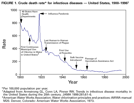
This number refers to the annual number of deaths per one thousand people. Demographers and statisticians use information to guide resources and money. The graph below is from the National Institute of Health and shows information about infectious disease in the US.
Our world contains many natural resources that we use to survive and some that we consume in the pursuit of our modern lifestyles. Air, water, and plant and animal life are all natural resources that we utilize in order to live. Rocks, minerals, and fossil fuels are examples of natural resources that we exploit to power our world and make technology possible. Wealth and status in the world economy are often determined by a nation’s access to natural resources. These resources can be classified as renewable, inexhaustible, and non-renewable.Renewable resources are, as the name implies, resources that can be renewed, usually through careful management or conservation. Most of the renewable resources used in the world today come from plant and animal material. Our food supply relies on numerous renewable resources. As long as the rate at which we extract living material for our food supply is the same as the rate that it is replenished, we need not worry about the future of this type of resource. However, history provides many examples of situations where demand exceeds supply and a food resource was exhausted. In many nations, conservation laws are enforced and agricultural methods are followed to ensure the future availability of food resources. Some of the renewable resources used by our society go toward the production of items such as clothing and housing. Cotton grown in the southern United States has provided a renewable resource used to make clothing and other material for many years. Timber harvested from carefully managed forests can provide the raw materials to supply future construction.The United States has a diverse energy production portfolio. The table below lists the types of fuels consumed in the production of electrical energy in our country.
| Electrical Generation by Fuel Type Consumed | |
|---|---|
| Coal | 52.3% |
| Nuclear Energy | 21.7% |
| Renewable Energy | 12.1% |
| Natural Gas | 10.7% |
| Residual Fuel | 1.8% |
| Electrical Imports | 1.2% |
| Distillate Fuel | 0.8% |
Soil, water, and air are other examples of inexhaustible natural resources. While these resources seem to exist in an unlimited supply, human activities that pollute or deplete these resources are still a cause for serious concern. For instance, fossil fuel combustion releases poisonous chemical compounds such as carbon monoxide into the atmosphere. Drinking water can be tainted by chemical and organic pollutants from industry. A significant percentage of drinking water is wasted each year in activities such as watering lawns, filling swimming pools, and flushing toilets. Conservation measures have been in place for many years to ensure the availability of clean soil, water, and air for future generations. As stewards of the environment, society must continue to attempt to reduce pollution and conserve our natural resources.With each passing year, our society’s demand for electrical energy increases. Therefore, it is crucial to find other resources that can provide uninterrupted energy for the future. Many decades ago, nuclear energy promised a future of clean unlimited energy. Currently, nuclear energy is unpopular because radioactive waste products usually do not break down for thousands of years. Even if they can be stored, they stay in the environment and pose a contamination hazard. Nuclear energy claimed to be an inexhaustible energy supply. However, there are other examples of inexhaustible energy resources that are environmentally friendly. Wind, solar, hydroelectric, and geothermal energy are all examples of inexhaustible natural resources. These types of resources help to reduce fossil fuel demand and provide energy through processes that do not create pollution.
Like all disciplines, geography has its share of terminology. Here is a brief overview:RotationThe spinning of the Earth on its axis; one rotation per 24 hours.RevolutionThe Earth’s orbit around the Sun; one every 365 days, 5 hours, and 12 minutes.Subduction trenchDeep underwater abysses. The Marianas Trench in the Pacific goes down 35,000 feet.FaultZone where the Earth’s tectonic plates grind together. (Also called transformation boundaries).Gradational forcesThese affect the Earth’s crust; they include erosion, weathering, and other forces.BoundaryThese can be either artificial like the ones drawn on a map, or physical, such as the Rio Grande River that separates the US from Mexico.ReliefThe variation in elevation from one place to another.ElevationThe height (or depth) above or below sea level.Cardinal directionsThey include north, south, east, and west. (Some would include the three directions between each of the four main cardinal directions. For example, between north and east lie north-northeast, northeast, and east-northeast.)Economic geographyThe study of the how geography affect economic conditions (and vice versa). For example, the Industrial Revolution effect on the urbanization of Great Britain.ClimateGeographers use this term to divide the Earth into zones of typical weather patterns, such as precipitation. Some climates include Alpine, Tropical, Arid, Temperate, and Polar.