In this lesson, we are going to cover the important features of our Earth.
We earlier reviewed the basic concepts of astronomy, including tools of the trade, our solar system, and the age of the universe.
In the second century BC, Eratosthenes calculated the size of the earth using simple geometry and measurements from the angles of shadows cast in two places. His calculations were amazing accurate. Some known characteristics of Earth:
Since surface material density is 2.7 g/cm3 the core must be more dense and is assumed to have a molten layer from earthquake evidence. Seismic vibrations travel though molten materials differently than from solid materials. The core is believed to be iron, nickel, or a combination of both. The core’s temperature is over 2000K and under very high pressure.
Circumference of the Earth at equator is about 38,625 km (or about 24,000 miles). Since the earth rotates on its axis once every 24 hours at the equator you are traveling about 1,600 km (or 1000 miles) per hour. Seems like we would fly off at that speed, but gravity keeps us here.
Time (for us) is dependent on the Earth and the sun. One earth rotation on its axis is one day. There are 365 ¼ days in 1 year or one trip of the Earth around the sun (revolution).
The tilt of the earth on its axis and the revolution of the earth around the sun produces our seasons. Summer is when the sun’s rays are most direct. Summer is June, July, and August in the northern hemisphere, and in the southern hemisphere summer is December, January, and February.
The early universe was very hot. The cosmic microwave background radiation is thought to be the remnant heat leftover from the Big Bang.
The Earth rotates through 1 degree every 4 minutes or 15 degrees every hour which is what defines the time zones. These lines marking every 15° are called longitude lines. They start in Greenwich, England, (0° longitude – the Prime Meridian) and move westward. This imaginary line that runs through the city’s Royal Observatory and marks time for the entire world has been in place since 1884. 180° from the Prime Meridian and half way around the world is the International Date Line where days begin and end.
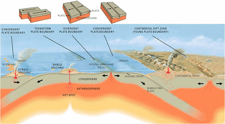
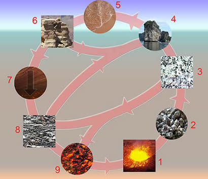
The surface of the earth is covered by what is labeled the crust. This is divided into two types: the continental and oceanic crusts. Because the density of the water is less than the density of the continent, the water floats on top of the continental crust. The oceanic crust is crust covered by ocean by virtue of its elevation. The oceanic crust is a little denser than continental crust as well as being much thinner.
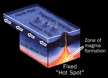
The continental crust is formed as volcanic magma cools on the surface. Most of this volcanic activity is found in subduction zones where one plate is being pushed under another plate. As this liquid rock erupts, it spreads and repeatedly covers the surface in layers, and more continental crust is built up. Over time, particulate materials are carried by the wind or water and deposited on the surface along with seeds dropped by birds or carried by the wind or water. With time, plants grow and stabilize the surface. The Hawaiian Islands are good examples of land that was formed by volcanoes and populated this way. However, these islands are far away from subduction zones and are thought to be directly over what is called a “hot spot” (more than 3,200 km from the nearest plate boundary). Evidence that supports the explanation for this can be found by investigating the age of the island rocks. Those islands farthest from the active volcano are also the oldest.
These areas can further be changed over time by wave action such as the New Orleans area where sediments are actually moved from the Mississippi river delta and deposited on Texas coastlines over time because of the currents in the Gulf of Mexico.
A result of the man-made levees that prevent the natural distribution and deposition of material through normal flooding is that the city of New Orleans is now actually below sea level and must be maintained that way with a pumping system. An event such as hurricane Katrina has the ability to re-establish the natural equilibrium, however humans call it a catastrophe because of the deleterious results to human endeavor.
The oceanic crust is formed in a similar way, that is, hot magma rises in areas to produce sea floor spreading. The mid Atlantic ridge is an area that evidence confirms the age of the rocks increase with increasing distance from the trench. It is believed that the mid Atlantic Ridge averages a rate of about 2.5 centimeters per year. This crust also disappears at a similar rate in subduction zones at the boundaries of the plates. How old are the oldest rocks on earth? According to most radiometric dating techniques, the oldest rocks are about 4.5 billion years old. These techniques have limitations in their accuracy however.
The spreading zones can clearly be distinguished from the subduction zones with their trenches.
The Earth is not a uniform solid object; it is composed of a series of layers of varying densities and characteristics. Our planet is made up of many constituent elements and compounds that are responsible for the components and physical properties of the planet we call home. The main layers are:
Describe the constituency of the Earth.
The correct answer is C. We know from seismic wave, microwave, and sonar analyses, that the Earth is not a uniform solid, but an interactive series of layers with different properties and materials.
Dichotomous keys are an excellent tool to help scientists identify virtually anything by means of a series of choices based usually on the presence or absence of particular characteristics. For example, if we wanted to identify a rock that we found on a geology field trip, we would start out using some of the most basic characteristics of the rock in order to narrow the realm of possibilities. One such choice early-on in any rock or mineral key is coloration. Is the rock black or contain black particles? Is the rock brown or contain brown particles? And so on. After each choice, there would be a yes or no dichotomy, hence the name, dichotomous key. There are many such keys freely available and we encourage you to explore various resources at your disposal in order to find a simple and useful guide or dichotomous key for use in your classroom. Another useful exercise is to have students make a dichotomous key.
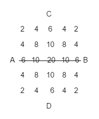
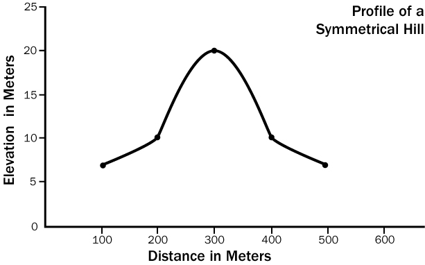
Contour maps are used to study the relative elevations of areas and can easily be interpreted with a little practice. By making careful measurements with a hand held GPS unit and a tape measure, a grid can be constructed of an area. This grid was constructed every 100 meters. The finer the grid, the more precise the contour map can be produced. Each number on the grid represents a vertical height in meters as well. Here is a simple example: