The purpose of this lesson is to explore the topography and hydrology of the oceans.
The World Ocean is a large interconnected body of seawater that contains the majority of water in the hydrosphere. Divided by continents and other geographic features, the World Ocean is a combination of five major oceans: the Pacific Ocean, the Atlantic Ocean, the Indian Ocean, the Arctic Ocean, and the great Southern Ocean. The World Ocean covers more than 361 million square kilometers of the Earth’s surface and contains almost 1,370 million cubic kilometers of water. That is a lot of water! Because of water’s properties as an energy-storing agent, this amount of water is probably the single most important regulator of our planet’s climate.
An ocean can be described geologically as an area of the Earth’s crust that is covered by deep water. For much of human history, the depths of the ocean were completely unknown territory, hidden from view by huge amounts of water. Today, we live at a time when the ocean floor has been mapped in great detail by technology such as sonar and by measuring minute gravitational fluctuations. The topography of the ocean floor reveals many geographic features that are identical to those found on land, such as mountains, plains, and valleys.
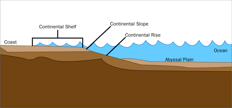
The continental shelf
Where a continent meets the sea is a region called the continental shelf. The depth and area of the continental shelf varies with location. The continental shelf ends in a sloped area called the continental slope. This gently sloped area sometimes ends with a more steeply sloped region called a rise. Canyons below the ocean scar many continental slope regions. These V-shaped canyons are often carved by strong ocean currents or by undersea earthquakes. The continental slope eventually levels out into the ocean basin.
The topography of the ocean basin varies across the floor of the ocean. Extending from the edges of the continental slope are the abyssal plains. These relatively flat regions range at depths from 3 to 6 kilometers below sea level. The abyssal plains are found in all major oceans and normally extend across the ocean floor to the mid-oceanic ridges. The abyssal plains are composed of sedimentary accumulations and decomposing organic material. Much of the Atlantic Ocean basin is abyssal plain, and is markedly more so than in the Pacific Ocean. One of the reasons for this is that most of the world’s rivers empty into the Atlantic Ocean, but this difference also arises from the Pacific Ocean basin, which is ringed with trenches that collect sediment from river flows.
Trenches are created by the action of plate tectonics. For example, the Pacific plate (also called the Pacific basin) moves westward, underneath the Eurasian plate. It is in this kind of subduction zone that you find trenches. Trenches are the deepest features found in oceans. The deepest trench is the world is the Marianna Trench in the Pacific Ocean, at a depth of almost 11,000 meters.
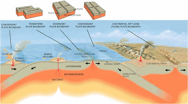
Trenches are found in subduction zones formed by convergent boundaries (where plates slide toward each other).
The collisions of undersea crustal plates also build mountains on the ocean floor similar to those above sea level. However, the largest underwater mountains are built through volcanic eruptions. These seamounts are produced when mounds of volcanic material build-up and poke up from the ocean depths to form island chains. The best example of this is the string of Hawaiian Islands. The Islands are still being made as the Pacific plate slides westward across a volcanic hot spot in the Earth’s crust, leaving behind a curved trail of islands.
Mid-ocean ridges are examples of divergent plate boundaries (where two plates spread apart).
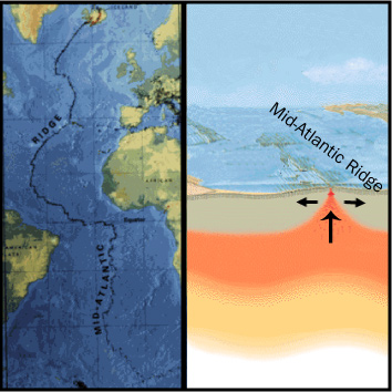
Another plate tectonic feature found on the ocean floor is the mid-oceanic ridge. In the 18th century, Benjamin Franklin and others proposed that the continents of Africa and South America were joined together in the distant past. It was not until the 20th century that this idea was shown to be correct when sonar measurements confirmed the existence of a spreading fissure in the Earth’s crust under the Atlantic Ocean. Magma arose from the depths to fill this crack in and solidified. Eventually the pressure built up, causing the surrounding area to rise and buckle. This continued to form other magma-filled cracks and bordering mountain ranges.
In effect, it would seem that the ocean floor is spreading out from the middle of the Atlantic Ocean. The continents on both sides of the Atlantic Ocean have been moving away from each other at the rate of 5 centimeters per year for the past 20 million years.
The topography of the ocean floor plays an important role in the movement of water across the globe. Other factors that influence the circulation of water include surface currents, deep ocean currents, and the tides. Surface currents move horizontally across the uppermost layers of the ocean. Theses layers are well mixed by wind, rain, and other weather phenomena. Wind is the primary mechanism that drives surface currents. Other contributing factors of ocean currents are the Earth’s rotation and the location of landmasses.
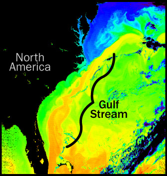
Surface currents distribute heat energy through the oceans and around the globe, which in turn helps to moderate the global climate. The current patterns in the northern hemisphere typically rotate in a clockwise direction while those in the southern hemisphere rotate counter-clockwise. Ocean current systems transport warm water from the equator towards the poles. As this warm water flows near a continent, it influences the coastal climate. The weather on the eastern United States is influenced by the warm Gulf Stream, which causes the coastal climate to be warmer on average. The opposite is the case for the western coast of the United States. The west coast climate is moderated by the cool North Pacific current that brings cold water down from the north towards the equator, resulting in a cooler coastal climate.
Deep ocean currents are huge vertical movements of water that start as a sinking of very cold water at the poles. This water sinks because it becomes colder and saltier at the poles, causing its density to increase. These dense waters move slowly outward from the poles (mostly from the north Atlantic) and across the bottom of the ocean. This circulation of deep, dense water is somewhat like a conveyor belt that transports huge amounts of water from the cold polar regions to other parts of the World Ocean. When these waters become warm again, they rise towards the surface and bring valuable nutrients to microscopic sea life (e.g., phytoplankton). Upwelling currents create a similar effect near continental boundaries.