The purpose of this lesson is to discuss the hydrologic cycle and its role in moving water from land to sea and back again.
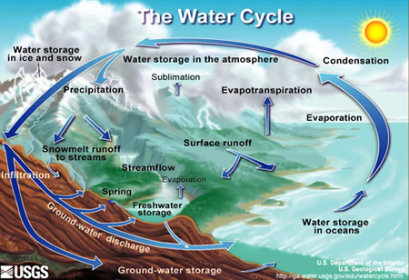
The hydrologic cycle is a combination of many different processes that circulate water through the hydrosphere. Most of the processes involve water’s ability to change its physical state (solid, liquid, or gas) at a variety of atmospheric temperatures and pressures. The hydrologic cycle involves continuous water interactions between the atmosphere, land, underground, and through plant life on the surface. Crucial to this cycle is the availability of places to store large amounts of water, such as aquifers, lakes, and oceans. The mechanisms that drive the hydrologic cycle are evaporation, transpiration, sublimation, condensation, precipitation, infiltration, discharge, and runoff.
Large-scale movements of water and ice across the continent cause erosion and are responsible for many kinds of eroded features. U-shaped valleys are commonly found in northern latitudes. These valleys formed when glaciers cut deep grooves into the surface as they advanced and retreated across the landscape during the ice ages. Glaciers are large masses of ice that form during long periods when the climate allows more snow to accumulate in winter than melts in the spring. The accumulations of snow compress into ice over time. Gravity pulls on the glacier as the weight of the ice increases, causing it to move slowly downhill. As these glaciers move, they erode the landscape with tremendous force, picking up large amounts of sediment and sometime very large rocks. When the glacier melts, these sediments and rocks are deposited sometimes hundreds of miles from their starting place. Melting glaciers contribute a great deal of freshwater to runoff on most continents. A recent concern has also focused on glaciers which contain millions of tons of methane frozen in their cores. As glaciers melt, they release what are called greenhouse gasses, creating potentially massive amounts of methane to be released into the atmosphere.
Melting ice, snow, and precipitation from high altitudes flows down hill, forming small mountain streams. These mountain streams combine with other streams at lower altitudes and eventually become part of large tributary systems that feed into major rivers moving across a continent. Under the influence of gravity, water in streams, creeks, and rivers cut deep channels into the surface. This erosion process is responsible for moving millions of tons of sediment towards the sea. As water transports these sediments across the continent, deposits can form natural levees and flood plains that can alter a river’s course over time. River and streams can occasionally overflow their banks in times of heavy rains and large snow melts. At these times, flood waters can further erode the landscape causing sheetwash and rill formation. When the river finally meets the sea, sediment carried for hundreds of miles by the river is dumped into the ocean in a fan-shaped formation called a delta. If the river has existed for a sufficient period of time, the sediment dumped in the river delta can form a complex of islands. Over time, these river sediments can slide down the continental shelf and collect on the ocean basin inside deep sea trenches.